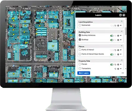
Core Datasets
Comprehensive and Accurate Building Footprint Data
Combined with hundreds of other property attributes, LightBox Building Footprint Data provides highly detailed and accurate building footprint information, essential for real estate professionals, urban planners, developers, and researchers. With nationwide coverage, our data includes precise outlines and attributes of buildings, ensuring efficient workflows and informed decision-making.

Our Coverage

Features and Benefits
Detailed Building Footprints
Our data includes precise building footprint outlines for millions of properties, allowing for accurate property assessments and planning. This data is crucial for visualizing the built environment.
Building Attributes
We provide a comprehensive footprint of a building’s attributes, including building height, ground elevation, number of stories and more to provide in-depth information for analysis and decision-making.
Multi-Source Data Integration
Integration of data from various web sources, including satellite imagery, aerial photography, and authoritative sources, ensures comprehensive and up-to-date building footprint map.

Geospatial Accuracy
High-precision geospatial data allows for accurate mapping and analysis of building footprints. Includes coordinates and spatial relationships with other geographic features.
Access LightBox Building Footprint Data
Bulk Data Downloads
Download large datasets in various formats, including CSV, SHP, and GeoJSON, to suit your needs.
API Access
Access our data seamlessly through the LightBox API. Integrate building data into your applications and workflows with ease. Features include search by building ID, coordinates, and more.
LightBox Vision
LightBox Vision, our powerful mapping and property research tool, allows users to access building footprint data with ease.
Feature Service
Leverage our Feature Service to access building footprints data dynamically within your GIS applications with our CanMap service. The Feature Service allows for real-time querying and visualization of building footprints, ensuring you have the most current data at your fingertips.