In the fast-paced world of location-based analytics, manually geocoding addresses one by one is a time-consuming process that can quickly derail productivity. Whether you’re working with thousands of customer locations, planning delivery routes, or analyzing a property portfolio, Batch Geocoding is the game-changing solution for streamlining workflows and ensuring precision at scale.
What is Batch Geocoding?
Batch geocoding is the process of converting a large volume of addresses into precise geographic coordinates and linking them to real-world assets using unique identifiers like LightBox IDs. This capability has become indispensable across industries, powering applications in logistics, marketing, disaster planning, commercial real estate (CRE), and property management. By automating geocoding, businesses can transform their approach to location data, moving beyond tedious manual processes to achieve actionable insights quickly and accurately.
How Batch Geocoding Works
Batch geocoding simplifies the task of converting large datasets of addresses into geographic coordinates and other related information, typically through three straightforward steps:
- Upload Your Dataset: Start by uploading a CSV file containing the addresses you want to geocode. Batch geocoding systems are designed to handle large volumes of data efficiently.

- Processing the Data: Advanced geocoding algorithms queue and process the data, ensuring accuracy and consistency across the dataset.
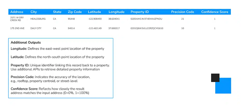
- Download the Results: After processing, you can download a completed CSV file enriched with geographic details such as latitude, longitude, and additional property-specific identifiers.

This streamlined workflow reduces manual effort, minimizes errors, and ensures data readiness for analysis or integration into mapping and decision-making tools.
While many providers offer batch geocoding, LightBox enhances the process by incorporating property insights and data enrichment capabilities designed to support industries such as real estate, insurance, and environmental due diligence. These additional features provide users with valuable context alongside geographic data.
Revolutionizing Geocoding for Complex Datasets
For organizations working with location data, batch geocoding offers a transformative leap in efficiency and accuracy. Instead of processing millions of addresses one by one—a labor-intensive and time-consuming task—batch geocoding streamlines the process, delivering faster and more precise results.
LightBox’s geocoding solution offers rooftop and unit-level precision, ensuring that even complex datasets are processed with unparalleled accuracy. Its scalability also means you can handle massive datasets without missing a beat, making it ideal for projects of any size.
Practical Tips for Effective Batch Geocoding
To maximize the benefits of batch geocoding, it’s important to start with clean, well-organized data. For instance, property names or address ranges might occasionally introduce challenges. Simplifying your data by removing extraneous details or standardizing address formats can greatly enhance the geocoding process.
Once your data is processed, take a moment to review any addresses that didn’t geocode successfully. Minor refinements, like correcting typos or clarifying unclear information, can make a big difference in achieving a complete and accurate dataset.
Real-Life Applications of Batch Geocoding
The power of batch geocoding becomes evident when applied to real-world scenarios. Take loan analysis, for instance. Inconsistent address formats can make it difficult to match past loan data with corresponding properties. By geocoding addresses into latitude and longitude coordinates—and linking them to property IDs—batch geocoding significantly improves match rates and enables deeper insights.
Another example is portfolio analysis. Imagine you’re analyzing an investment portfolio containing thousands of property addresses. Running the data through a batch geocoder transforms static information into actionable insights, allowing you to visualize geographic patterns and trends quickly.
A New Standard in Location Data
Whether you’re working with 100 addresses or a million, batch geocoding is an essential tool for modern data workflows. By combining efficiency, precision, and scalability, it empowers businesses to unlock the full potential of their location data. With this technology at your fingertips, you can process data with confidence, gaining the insights you need to drive smarter decisions.

